
After a holiday season filled with warm and sunny days, Oklahoma is now bracing for a historic cooldown this weekend. I am no weather expert, nor do I pretend to be. (Although my dream job is like that of Tyler Owens (Glen Powell) from “Twisters”). I am just here to convey information from trusted sources.
For some winter storms, the temperature hovers around freezing. This can limit the amount of snow and winter precipitation seen. Due to extremely low temperatures, this will not be a limiting factor in this storm. This storm will pack a punch in multiple ways. The information I am providing is mostly from the National Weather Service in Norman.
Extreme Cold:

Early Friday morning, temperatures in Weatherford will drop below freezing, and they may stay there for quite some time. We’ll see a rapid cooldown throughout the day on Friday.
Saturday’s forecasted high is just 7 degrees, and Sunday’s is only 20, but it’s the wind chills that will be a major cause for concern this weekend. At their coldest, feels-like temps may drop to 16 below zero.
Not only will it be extremely cold, but that cold will last for an extended period of time. Forecasts indicate the wind chill will stay below zero for nearly 48 hours, from midday Friday to Midday Sunday. High temperatures may not leave the 30s for at least a week after this event begins on Friday.
Snow and other winter precipitation:
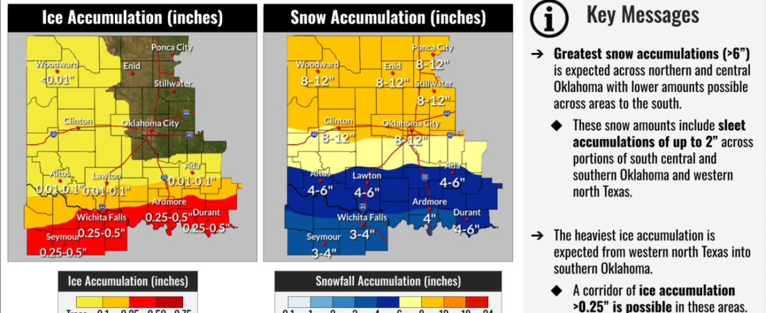
The big question winter lovers are wondering: Is it going to snow? The short answer is yes. But the longer answer may make winter lovers even more excited.

It is essentially impossible to forecast exactly how much snow we’ll receive from this storm, but ranges and percentages from models and experts can give us a decent idea. The National Weather Service in Norman has forecasted that much of northern Oklahoma, extending down to nearly i-40 to receive 8-12 inches of snow. These percentages could go up or down as the event gets closer, but that’s where we stand currently.
It has begun to become even more complicated for areas along I-40. Two waves of winter precipitation are expected. For the first wave on Friday evening, atmospheric temperatures may be slightly above freezing. This could lead to an extended period of sleet and not snow. For the second wave on Saturday evening into early Sunday, expect snow.
If anyone plans to travel south this weekend, do so with extreme caution, as the Red River Corridor into Texas could see extreme impacts from ice and sleet.
Stay tuned to road condition updates if you plan to travel. This is a dynamic situation, and even snow alone can have a massive impact on roads.
The big picture and how to prepare:

This storm could be historic for Oklahoma. Stay tuned for updates from trusted sources. In the meantime, remember to protect the three P’s during cold weather: Pipes (drip faucets and open cabinets to circulate the warm air), Pets (do not leave animals outside for long periods), People (dress in layers and cover exposed areas if you must be outside for periods).
Don’t panic-buy large amounts of milk and bread. Unless you just love French toast. In which case, buy away (and invite me, please!) But seriously, make sure you have the essentials. Check the link here for all the essentials you may need for a storm like this.
For weather updates, stick to trusted sources. I prefer the National Weather Service over Facebook Forecasters and YikYak truthers. Also, remember that weather apps are not the most accurate. Weather.gov provides the most accurate information.
Stick with The Southwestern on social media for updates on closures.
